Paleoseismic evidence of surface rupture of the 2005 Kashmir earthquake in
Pakistani Himalaya and coseismic generated slope conditions
Allah B. Kausar 1, Sardar S. Akhtar 1, Heitaro Kaneda 2, Hisao Kondo 2, Mohammad Latif 1,
Simon Sadiq 1 and Hamid Hussain 1
1Geological Survey of Pakistan, H-8, Islamabad, Pakistan
2Active Fault Research Center, AIST, Geological Survey of Japan
The geography of the Asia is severely affected by the ongoing collision of the Indo-Pakistan sub-continent with southern Eurasia. In the area of convergence between the two continental plates rapid bedrock uplift has resulted in the formation of the Tibet Plateau, the Himalaya mountain ranges, as well as the Karakoram, Pamir, and Hindu Kush ranges. Convergence between the two tectonic plates results in a series of large thrust faults in the foothills of these mountains. These include the Main Karakoram Thrust (MKT), the Main Mantle Thrust (MMT), and the Main Boundary Thrust (MBT), which appear to dip northeast below the mountain ranges.
Active mountain building is associated with frequent occurrence of extreme natural processes such as earthquakes, mass movements, floods and avalanches. These processes often interfere with each other and thus represent multiple natural hazards to inhabitants and infrastructure of mountainous areas and their vicinities. When large earthquakes, like the 2005 Kashmir earthquake, hit populated areas, no matter where on the globe, they yield casualties, sorrow, and destruction, and leave deep and everlasting signs in the lives of survivors. The 2005 Kashmir earthquake increased substantially our awareness of the need for active faulting studies in earthquake prone countries. On-land active faults have been causing large earthquakes, mostly destructive, producing surface ruptures that contributed to growth of tectonic geomorphic features.
Detailed mapping of coseismic surface rupture not only provides basic information to understand the earthquake cyclic history itself and to estimate its repeat interval, but adds fundamental insights for interpretation of tectonic geomorphic features elsewhere, from which future occurrence of a large surface rupturing earthquake is anticipated. More information and knowledge on thrusting surface ruptures thus needs to be accumulated for better understanding and more rigorous seismic hazard assessment of active
thrusts. However, for scientists, the occurrence of large earthquakes is the only way for testing present knowledge on earthquakes. At the same time it provides a new impulse towards a better understanding of these disastrous events.
The October 08, 2005 Kashmir earthquake of Mw 7.6 struck the northwestern margin of the Indian-Eurasian collision zone, providing a rare opportunity to study a fresh thrusting surface rupture. Although no surface ruptures have been found along the Himalaya since 1800, the 2005 event was accompanied by a distinctive and extensive thrusting surface rupture. The Balakot-Bagh earthquake rupture is complex, as befits most thrust earthquakes ruptures, with considerable shallow deformation in the hanging wall, but it is clear in most places. Most of the surface rupture faithfully follows the trace of a geomorphologically-evident active Balakot-Bagh fault.
The surface rupture trace, on which earthquake occurs, is generally not continuous, and is commonly composed of three geometrical segments separated by small steps. The mean vertical slip rate, horizontal shortening rate, and net slip rate of this fault are calculated to be 1.1-1.7, 1.9-2.9, and 2.3-3.3 mm/yr, respectively [1]. The horizontal shortening rate across the Balakot-Bagh fault is only 10-20% of the shortening across the Himalaya of 11.9 mm/yr [2] and 21 mm/yr [3] suggesting that the fault is not the major agent of the Himalayan contraction accommodation, but a relatively minor active fault formed on the overridden side, most likely rooted in the Main Himalayan Thrust (MHT).
Although the amount of remaining strain is unknown, it may be ready to be released by another earthquake on the Salt Range Thrust (SRT) or an active fault elsewhere. The detailed distribution of the active faults in the earthquake hit area is not well known. Therefore, the paleoseismic and tectonic background of the earthquake remains uncertain, despite the fact that such information will provide valuable knowledge concerning future earthquakes in the surrounding areas as well as seismotectonics of the Indian-Eurasian collision zone.
Several trenches have been excavated across the MHT [4, 5], although recurrence-interval data are sparsely distributed along the fault, the interval is estimated to be ca. 500-900 years, taking into account the lack of historical earthquake records. In contrast, the result of trench at Nisar Camp (Fig. 1), near Muzaffarabad, across the restraining step between the northern and central segments yields estimates of ca. 2000-2500 years, which is much larger than that expected for the tectonic setting of the collision zone
[6]. Observations evidence that 2005 Kashmir earthquake event did not occur on the MHT, but on intra-plate active faults inside the Sub-Himalaya.
The 2005 earthquake is thus interpreted as a rare event in that the accumulated strain across the Himalaya was released by a relatively minor intra-plate fault rather than plate boundary mega-thrusts within the Indian-Eurasian collision zone such as MHT. Earthquake hazards continue to cause great concern to the general public, and can pose serious hazard to property in the hillside terrain of the 2005 Kashmir earthquake hit areas. When the slides and earth flows move they deform and tilt the ground surface.
The result can be destruction of foundations, offset of roads, as well as overriding of property and structures down slope. The Kashmir earthquake involved slope failures in both bedrock and superficial deposits, with landslides occurring on many natural slopes and artificially cut slopes, particularly along transport routes [7]. The most detailed map [8] has been derived from mapping from SPOT 5 imagery; this has identified 2,424 landslides over an area of 55x 51 km (Fig. 2). The distribution of landslides appears to be very asymmetric and the most obvious landslides occur on the hanging wall of the fault associated with white dolomitic limestone in the area north and north-west of Muzaffarabad towards Balakot [9, 7, 8].
One major landslide occurred towards the south-eastern extent of rupture close to the town of Hattian Bala in a side valley of the Jhelum River valley system [10]. A temporary lake was formed when the slide dammed the Karli creek. Almost 200 people in and around Lodhiabad lost their lives. This disaster is one example of the destructive potential of landslides and why they are considered hazards. While not every landslide results in catastrophe, the damage from many small ones may equal or exceed the impact of a single major failure. Thus, both large and small landslides are capable of causing significant damage and loss of life.
The Geological Survey of Pakistan focus on the future evolution of the Kashmir area suggests that there is a high likelihood of many more landslides, and thus a substantial increase in loss of life. Determining the extent of landslide hazard requires identifying those areas which could be affected by a damaging landslide and assessing the probability of the landslide occurring within some time period. However, the presence of the cracked slopes also raises some fundamental questions about one of the key techniques for assessing the hazards associated with earthquake-triggered landslides. As a result, there is a high level of threat to the
population of Kashmir and NWFP, and the landslides represent a significant potential source of problems during the rehabilitation phase in the country.
References
- Kaneda, H., Nakata, T., Tsutsumi, H., et al., 2006.Asian Oceania Geosciences Soc. 10-14 July, Singapore
- Wesnousky, S. G., Kumar, S., Mohindra, R., and Thakur, V. C., 1999. Tectonics, 18, 967-976.
- Lavé, J., and Avouac, J.P., 2000. J. Geophys. Res., 105, 5735-5770.
- Kumar, S., Wesnousky, S.G., Rockwell, T.K., et al., 2001. Science, 294, 2328-2331.
- Kumar, S., Wesnousky, S.G., Rockwell, T.K., et al., 2006. J. Geophys. Res. 111, B03304, doi: 10.1029/2004JB003309.
- Kondo, H., Nakata, T., Akhtar, S.S., et al., 2006. (In press).
- Petley, D.N., Dunning, S.A., Rosser, N.J., and Kausar, A.B., 2006. Debris Mitigation of Debris Flows, Slope Failures and
- Sato, H.P., Hasegawa, H., Fujiwara, S., J., 2006. Landslides, DOI 10.007/s10346-006-0069-5.
- Fugiwara, S., Tobita, M., Sato, H. P., and Ozawa, S., 2006. In: Kausar, A. B., Karim T., and Khan, T. (eds.), International
- Conference on 8 October Earthquake in Pakistan: Its Implications and Hazard Mitigation: Islamabad, Geological Survey of Pakistan, p. 109-114.
- Harp, E.L., and Crone, A.J., 2006. US Geological Survey Open File Report 2006-1052, 13 p.
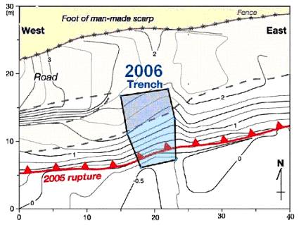
Fig. 1. Plan-view map of detailed surface ruptures around the trench site at Nisar Camp. Contour lines denote elevation at 0.25m
intervals (from Kondo et al, 2000).
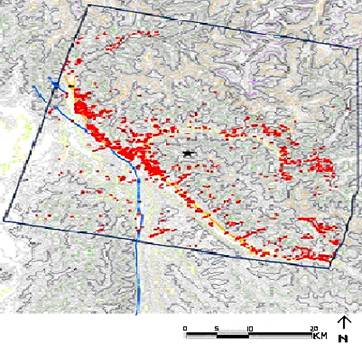
Fig. 2. Landslide distribution of post-seismic landslides interpreted from SPOT-5 imagery. Elevation data from SRTM (From Sato et
al., 2006). |